
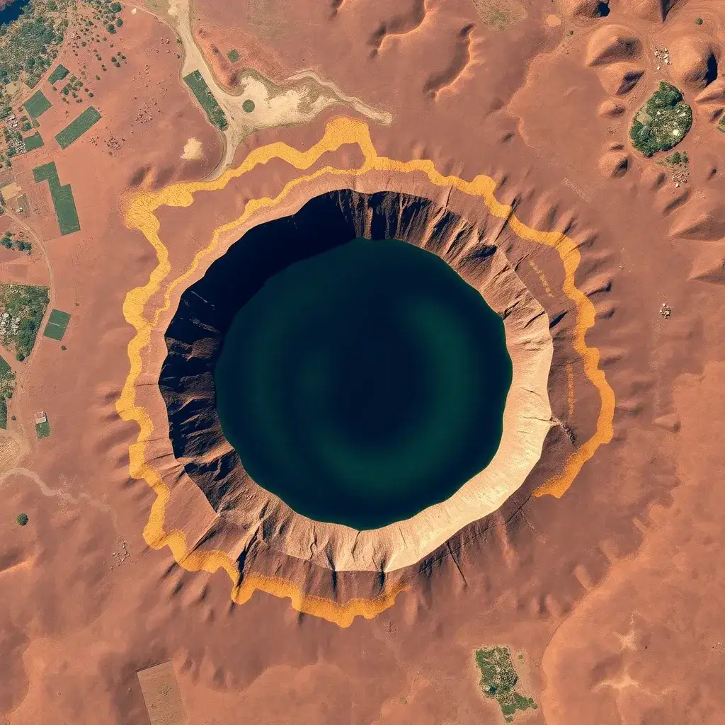
A recent satellite image captured by NASA’s Landsat 8 on December 21, 2024, reveals striking tendrils of gold surrounding Ghana’s sacred Lake Bosomtwe, a unique natural lake located southeast of Kumasi. This celestial view highlights exposed veins of gold, a direct consequence of geological processes initiated by an asteroid impact approximately one million years ago.
A Geological Marvel with Deep Roots
Lake Bosomtwe, Ghana’s sole natural freshwater lake, is a bowl-shaped body of water spanning 49 square kilometers and reaching depths of up to 70 meters. Its origins are steeped in both local folklore and scientific consensus. According to oral traditions, the lake was discovered by a hunter named Bompe, whose pursuit of an antelope led him to a small pond that miraculously swelled into the vast lake after the antelope vanished into its waters. This narrative led to the belief that the site housed a sacred god, hence the name ‘Bosomtwe,’ meaning ‘antelope god.’
However, modern geology offers a more explosive explanation. Scientists posit that Lake Bosomtwe formed around one million years ago when an asteroid, approximately one kilometer wide, struck the Earth. This cataclysmic event created one of the youngest and best-preserved complex impact craters on the planet. The impact would have unleashed immense energy, incinerating life for dozens of kilometers and potentially obliterating the present-day city of Kumasi.
The Gold Legacy of an Asteroid Strike
The asteroid impact not only sculpted the landscape but also brought valuable resources to the surface. The immense shockwave fractured the Earth’s crust, allowing mineral-rich magma to rise. This geological activity created shallow veins of gold and other precious elements, which have been a source of livelihood for local communities for generations. The ‘galamsey’ tradition, a form of small-scale gold mining, has long been practiced in the area, concentrating minerals near the surface.
Remote sensing analysis, as noted in a Yahoo News article from May 26, 2026, indicates that the material ejected from the impact settled in a ‘rampart’ crater pattern. This suggests the area was saturated with groundwater during the collision. Rampart craters, though rare on Earth, are common on other celestial bodies, making Lake Bosomtwe a potential analog for understanding extraterrestrial crater formation.
Accelerated Mining and Visible Changes
Recent satellite imagery, including the December 21, 2024 photo, demonstrates a significant increase in gold mining activities around Lake Bosomtwe. Advances in technology have accelerated the rate of extraction, leading to more visible gold deposits being exposed. A comparative image from December 29, 2015, shows a marked expansion of mining operations, particularly southwest of the lake, alongside the rapid growth of farmland and villages encroaching on the crater rim.
The increasing human activity has also led to visible changes in the lake’s water. The greener hue observed in the 2024 image is attributed to higher concentrations of certain types of phytoplankton. While phytoplankton levels naturally fluctuate seasonally, research suggests that land-use changes near the lake, including deforestation and agriculture driven by mining, may be contributing to increased nutrient loads, thereby favoring the proliferation of specific phytoplankton species.
Technological Monitoring and Environmental Concerns
To address the growing concerns surrounding mining and land use, a team of NASA-funded scientists developed a mobile application. This app utilizes Landsat imagery to monitor the expansion of gold mining in the region, distinguishing between artisanal and industrial-scale operations. Artisanal mining, while often more superficial, can lead to extensive deforestation and mercury contamination of waterways, posing significant environmental risks.
Senior lecturer Marian Selorm Sapah from the University of Ghana’s Department of Earth Science commented on the striking juxtaposition of human-induced changes against a million-year-old geological landmark. She noted the clear encroachment of settlements, agriculture, and mining activities right up to the lake’s steep crater rim, a testament to both the image resolution and the scale of environmental transformation occurring around this ancient site.
Looking Ahead
The evolving landscape around Lake Bosomtwe, as captured by sophisticated satellite technology, underscores the dynamic interplay between geological history, natural resources, and human activity. Future observations will be crucial in tracking the sustainability of mining practices, the impact on the lake’s ecosystem, and the effectiveness of monitoring tools in managing these changes. The continued study of this unique impact crater may also offer further insights into planetary geology and the formation of craters across the solar system.









Leave a Reply